Visitors' Guide
Accommodations
Arts & Entertainment
Dining
Parks & Campgrounds
Recreation
Services
Shopping
Sightseeing
Member Opportunities
Meeting & Event Planning
Group Tour Planning
The Press Room
Getting To Bucks County
Industry Partners
Home
|
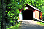
Covered Bridges of Bucks County
Cabin Run Covered Bridge
Location: Covered Bridge Rd., Plumstead Twp.
Height Limit: 11 ft. 10 in. Width: 15 ft.
Length: 82 ft. Weight Limit: 3 tons
 UILT in 1871, this bridge crosses the Cabin Run Creek, and is located a short distance downstream from the Loux Covered Bridge.
Frankenfield Covered Bridge UILT in 1871, this bridge crosses the Cabin Run Creek, and is located a short distance downstream from the Loux Covered Bridge.
Frankenfield Covered Bridge
Location: Hollow Horn and Cafferty Rd., Tinicum Twp.
Height Limit: 11 ft. 3 in. Width: 12 ft.
Length: 130 ft. Weight Limit: None
UILT in 1872, the Frankenfield Covered Bridge crosses Tinicum Creek only two miles upstream from where the creek flows into the Delaware River. This bridge is one of the longest covered bridges in the County.
Erwinna Covered Bridge
Location: Geigel Hill Rd., Tinicum Twp.
Height Limit: 11 ft. Width: 15 ft
Length: 56 ft. Weight Limit: 29 tons
 LTHOUGH the National Historic Register lists the date built as 1871, county records suggest this bridge was built in 1832. The Erwinna Covered Bridge is a good example of the lattice-type construction and is Bucks County's shortest covered bridge. It crosses Lodi Creek.
Knecht's Covered Bridge LTHOUGH the National Historic Register lists the date built as 1871, county records suggest this bridge was built in 1832. The Erwinna Covered Bridge is a good example of the lattice-type construction and is Bucks County's shortest covered bridge. It crosses Lodi Creek.
Knecht's Covered Bridge
Location: Knecht's Rd., Springfield Twp.
Height Limit: 11 ft. 6 in. Width: 15 ft.
Length: 110 in. Weight Limit: 3 tons
UILT in 1873, this bridge is also known as "Slifer's Bridge". Built of hemlock, it crosses Durham Creek which was once known as "Cook's Creek".
The Loux Covered Bridge
Location: Wismer Rd., Plumstead Twp.
Height Limit: 11 ft. Width: 15 ft.
Length: 60 ft. Weight Limit: 15 tons
UILT in 1874, of hemlock, nestled in a scenic valley, you'll find this bridge is one of two bridges to span the Cabin Run Creek.
Mood's Covered Bridge
Location: Blooming Glen Rd., E. Rockhill Twp.
Height Limit: 11 ft. 2 in. Width: 15 ft.
Length: 120 ft. Weight Limit: None
 UE to repairs, Mood's
Covered Bridge, located on BloomingGlen Road in
East Rockhill Township, will be closed until further notice. We apologize
for any inconvenience this may cause.
Pine Valley Covered Bridge UE to repairs, Mood's
Covered Bridge, located on BloomingGlen Road in
East Rockhill Township, will be closed until further notice. We apologize
for any inconvenience this may cause.
Pine Valley Covered Bridge
Location: Old Iron Hill Rd., New Britain Twp.
Height Limit: 11 ft 10 in. Width: 15 ft.
Length: 81 ft. Weight Limit: None
UILT in 1842 of native hemlock and pine, the bridge is also known as "Iron Hill Bridge". The bridge crosses Pine Run Creek which was named after the hardy neighboring pine trees.
Sheard's Mill Covered Bridge
Location: Covered Bridge Rd., between Haycock and E. Rockhill Twps.
Height Limit: 12 ft. 1 in. Width: 15 ft.
Length: 130 in. Weight Limit: None
UILT in 1873, this bridge spans Tohickon Creek.
Schofield Ford Covered Bridge
Location: Tyler State Park, off Swamp Rd., Newtown Twp.
Height Limit: 13 ft. Width: 16 ft.
Length: 170 ft. Weight Limit: No Vehicle Access
 RIGINALLY built in 1873, burnt down in 1991, rebuilt in 1997. Built of native hemlock and oak, this town truss bridge is the longest in Bucks County. Also known as "Twining Ford Bridge", it crosses Neshaminy Creek.
South Perkasie Covered Bridge RIGINALLY built in 1873, burnt down in 1991, rebuilt in 1997. Built of native hemlock and oak, this town truss bridge is the longest in Bucks County. Also known as "Twining Ford Bridge", it crosses Neshaminy Creek.
South Perkasie Covered Bridge
Location: Lenape Park, Walnut St., E. Rockhill Twp.
Height Limit: No Vehicle Access Width: 15 ft.
Length: 93 ft. Weight Limit: No Vehicle Access
UILT in 1832 of pine and oak, this bridge once crossed Pleasant Spring Creek until it was condemned to traffic.
Uhlerstown Covered Bridge
Location: Uhlerstown Rd., Tinicum Twp.
Height Limit: 11 ft. 3 in. Width: 15 ft.
Length: 101 in. Weight Limit: None
UILT in 1832, this bridge is built of oak and has windows on both sides. It is the only covered bridge that crosses the Delaware Canal.
Van Sant Covered Bridge
Location: Covered Bridge Rd., Solebury Twp.
Height Limit: 12 ft. 6 in. Width: 15 ft.
Length: 86 ft. Weight Limit: 7 tons
UILT in 1875, and also known as "Beaver Dam Bridge", this bridge crosses Pidcock Creek. You'll find this bridge is close to Bowman's Hill and the Thompson-Neeley House, part of Washington Crossing Historic Park.
|
|
|
|
Note: L =
Left, R = Right. Bridges are accessible by car and most mini vans.
3 Bridge Tour—
Pine Valley, Mood's &
South Perkasie Bridges
Starting Point: Rt. 313 (Swamp Rd.) & Ferry Rd., Fountainville.
Go west on Ferry Rd. 3.2 mi. Turn L onto Old Iron Hill Rd. And go 0.5 mi. to Pine Valley Bridge. Park in parking lot on other side of bridge. Note: Peace Valley Park & the National Shrine of Our Lady of Czestochowa are nearby. Go back through bridge on Old Iron Hill Rd. 0.5 mi. Turn L onto Ferry Rd & go 0.5 mi. to stop sign. Turn R onto Callowhill Rd. & go 4.0 mi. to dead end at stop sign. Turn L & immediately R to continue onto Callowhill Rd. & go another 2.7 mi. At stop sign, turn R onto Branch Rd. (Branch Rd. west of Callowhill Rd. is Main St.) & go 0.8 mi. (no street sign, stone house is on corner). Turn L onto Blooming Glen Rd. & go 0.1 mi. to Mood's Bridge. Go through Mood's Bridge & go 0.3 mi. on Blooming Glen Rd. At light, turn L onto 5th St. & go 1.4 mi. Turn L onto Walnut St. & go 0.2 mi. Turn R into Lenape Park; South Perkasie Bridgeis on the left. When you leave the park, turn L onto Walnut St. & go 0.2 mi. Turn R onto 5th St. & follow 5th St. east 3.2 mi. to Rt. 313. Turn R onto Rt. 313 (Swamp Rd.) to return to Fountainville.
5 Bridge Tour—
Loux, Cabin Run, Frankenfield,
Erwinna & Uhlerstown Covered Bridges
Starting Point: Rt. 413 (Durham Rd.) and Stump Rd., Hinkletown
Go east onto Stump Rd. 0.9 mi. Turn L onto Wismer Rd. (farmhouse on corner) and go 1.0 mi. to Loux Bridge. Note: Carversville-Wismer Rd. becomes Wismer Rd. in this area. Continue through bridge up hill 0.5 mi. to stop sign. Turn R onto Dark Hollow Rd. and go 0.9 mi. Turn R onto Covered Bridge Rd. and go 0.6 mi. to Cabin Run Bridge. Note: Ralph Stover State Park and Stover-Myers Mill Park are nearby. Go back on Covered Bridge Rd. to Dark Hollow Rd. Instead of turning L onto Dark Hollow Rd., stay straight ahead and follow the road around Stover-Myers Mill and go 2.7 mi. Turn L onto Cafferty Rd. (brownstone houses on corner) and go 0.6 mi. to Frankenfield Bridge. Go through bridge and uphill 0.2 mi. Turn R onto Hollow Horn Rd. and go 1.3 mi. until the stop sign. Turn R onto Headquarters Rd. (stay left at curve) and go 1.0 mi. until the stop sign. Turn L onto Geigel Hill Rd. & go 0.2 mi. to Erwinna Bridge. Note: Tinicum Park & Erwin Stover House are nearby on Rt. 32. Turn around & go back through Erwinna & stay straight on Geigel Hill Rd. 0.5 mi. until the stop sign. Turn L onto Rt. 32 (River Rd.) & go 1.7 mi. Turn L onto Uhlerstown Rd. & go 0.3 mi. to Uhlerstown Bridge. Turn around & return to Rt. 32 (River Rd.), turn R & return via Rt. 32 towards New Hope.
Download 2002 Bucks County Map
Call the Bucks County Conference & Visitors Bureau, Inc.
to plan your covered bridge tour today! |

|
|
|
|
|